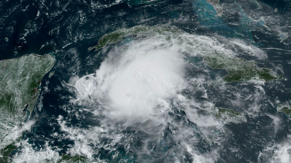
Beryl foreshadows future hurricanes, says UN weather agency / Photo: Jose ROMERO - NOAA/RAMMB/AFP
The World Meteorological Organization, which is tracking Hurricane Beryl's deadly course through the Caribbean, told AFP that more storms with its hallmarks could be expected in the future.
The WMO, the United Nations' weather and climate agency, said the record-breaking tropical cyclone intensified rapidly, picking up energy over a warmer Atlantic Ocean and developing into a system with lots of heavy rain.
Anne-Claire Fontan, scientific officer at the WMO's tropical cyclone programme, said that Beryl signals a very active Atlantic hurricane season in 2024.
- How did Beryl develop? -
"It developed quite quickly in an area which was unusual for this time of year.
"It reached category 4 in June; that was the earliest we've ever seen. It reached category 5 quickly afterwards, so there is a very rapid intensification.
"It reached category 5 very early in the season. It's really very unusual. Hurricane Beryl really broke records.
"For more than a year, there has been a significant positive anomaly of hot water in this area.
"So that's a lot of energy for cyclones, since they feed on the energy of the ocean.
"With such a powerful system, this early in the hurricane season, it suggests... a very active season for 2024."
- Where will Beryl go next? -
"Beryl will head towards the Yucatan peninsula.
"We are expecting violent winds even if Beryl is expected to decrease in intensity.
"And then it's expected to come out into the Gulf of Mexico.
"There is a little more uncertainty on its trajectory after passing over the Yucatan, recognising that when a hurricane is cut off from... the ocean... it will probably weaken enormously.
"By returning to warm waters, it could intensify. So this is where there is uncertainty... It remains to be seen whether it will be Mexico or Texas (afterwards)."
- How will climate change affect hurricanes in future? -
"Beryl is an illustration of what we can expect in the future: systems which intensify rapidly with a lot of energy at the ocean level, therefore category 5 systems with a lot of rain.
"A warmer world with global warming does not necessarily mean more tropical cyclones... in terms of frequency.
"(But) we expect a shift towards much more powerful systems -- so with much higher winds.
"Another factor is that in a warmer atmosphere that is capable of retaining more moisture, there will be increased rain associated with tropical cyclones."
- What will their impact be? -
"The categorisation of hurricanes relies on wind speeds, but the... dangers (are heavily linked to) rain, with all the hazards it brings, in the form of mudslides, flash floods. All of that will also increase.
"The sea level is rising. Tropical cyclones are associated with storm surges... which can cause catastrophic flooding when they make landfall, depending on the layout of the coast.
"So if the storm surges arrive with an already increased sea level, you can clearly see the flooding this can also cause.
"We have a huge population living near the coasts worldwide. So it will clearly be a problem to manage the populations at the coast."
- A longer hurricane season? -
"When it comes to what will happen to tropical cyclones in a warming world, in terms of a longer season, there is no information at the global level.
"On the other hand, studies have been carried out at the regional level... which show that the season may be extended."
- Are systems geared to track such cyclones? -
"Trajectory-level tropical cyclone forecasts have improved significantly.
"There is room for improvement in terms of intensity forecasting, and in particular rapid intensification.
"Rapid intensifications are not yet well understood by digital weather forecast models. The scientific community is constantly working on this."
- How should vulnerable countries prepare? -
"It is very important that all countries do hurricane preparedness, in other words that they sensitise their population to the dangers presented by tropical cyclones, (explaining) how they should react depending on the degree of danger.
"Preparing really means systematically educating the population in advance to know how to act, to prepare their house, then the family; knowing where the shelters are."
(T.Burkhard--BBZ)