
New LiDAR Survey Validates & Supports Grande Portage Resources' Development Plans at the New Amalga Gold Project - Updated Project Summary
VANCOUVER, BC / ACCESS Newswire / November 24, 2025 / Grande Portage Resources Ltd. (TSXV:GPG)(OTCQB:GPTRF)(FSE:GPB) ("Grande Portage" or the "Company") is pleased to announce that it has received survey data from an aerial LiDAR scan at the New Amalga Gold property in Southeast Alaska, a critical input for advancing engineering and environmental work at the project.
LiDAR (Light Detection and Ranging) is a high-resolution, laser-based mapping technique which uses rapid pulses of laser light and precise time-of-flight measurements to calculate the distance to surrounding surfaces. By sweeping the laser across an area and recording millions of return points, it generates a dense "point cloud" that represents the 3D geometry of terrain, vegetation, or objects (Fig. 1 below).
This aerial scan, conducted by an Anchorage-based team from NV5 Geospatial, covers the area of potential project infrastructure development and access road corridor. The new survey validates the planned locations of the mine's surface facilities and compliments a previous scan which covered the area surrounding and directly above the resource veins.
LiDAR data is critically important for a variety of engineering, environmental, and exploration purposes including:
Determining optimal locations for buildings and roads to minimize the amount of earthworks and surface disturbance
Identifying natural drainage channels and potential wetland areas to be subsequently confirmed by field surveys
Determining the density of vegetation and the height of the tree canopy relative to the ground surface (Fig. 2 below)
Mapping large-scale geotechnical features and structures where bedrock is exposed to inform mine design
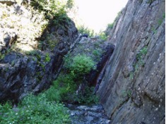
Identifying small channels and gullies where an exposed vein has preferentially eroded relative to the wall rock, a valuable exploration tool to identify potential vein outcrops (Fig. 3 below)
Ian Klassen, President and CEO comments: "Modern LiDAR scanning is an extremely valuable technology for the New Amalga Gold project, enabling surface data to be collected with an extremely high degree of detail in a short period of time. This results in more precise early engineering work while focusing and expediting our fieldwork and environmental data collection efforts, key factors enabling the project to advance through the regulatory process and towards mine development."
The New Amalga Gold Project remains open to expansion in multiple directions and hosts an Indicated Resource of 1,438,500 ounces of gold at an average grade of 9.47 g/t Au (4,726,000 tonnes) and an Inferred Resource of 515,700 ounces of gold at an average grade of 8.85 g/t Au (1,813,000 tonnes). The current development concept envisions a small-footprint underground mining operation with third-party offsite processing, eliminating the need for an onsite mill or tailings storage facility.
Fig. 1: LiDAR Scan Data Enables an Extremely Precise 3-D Surface of the Project Area
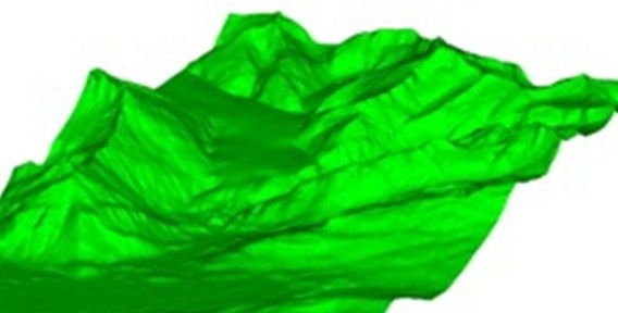
Fig. 2: LiDAR Data Distinguishes between Vegetation and Bare Earth, Enabling an Understanding of Vegetation Cover and Tree Canopy Height
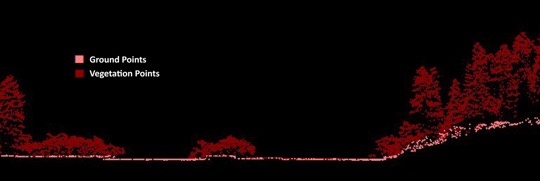
Fig. 3: Example of "Gully" or "Channel" Formed by Preferential Erosion of Vein Outcropping
Project highlights:
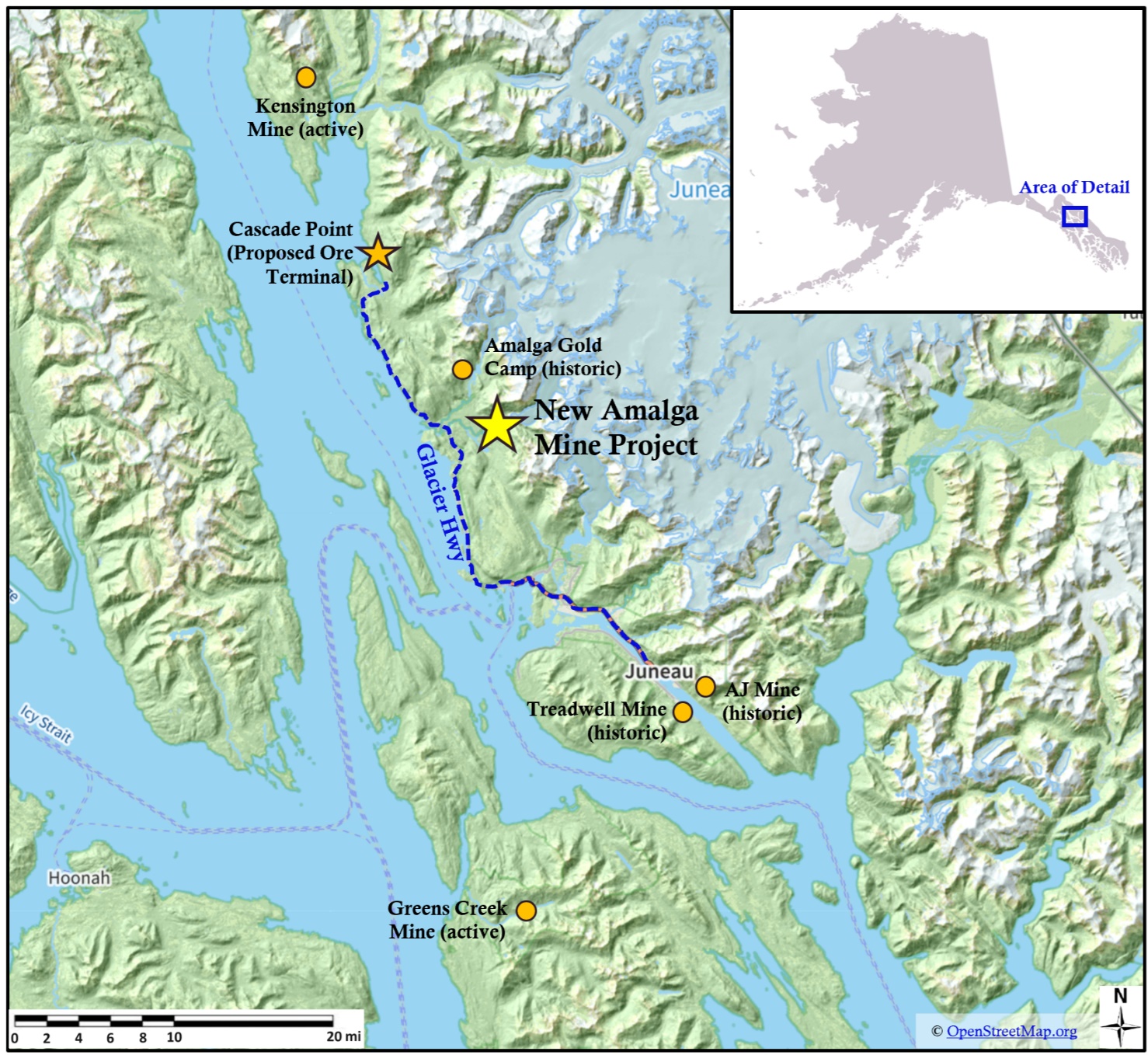
A 100% interest in the New Amalga Gold Project, located near infrastructure only 25km north of Juneau, Alaska and 6km from paved all-season highway (Fig. 5)
The property is host to at least 8 large, long, gold bearing mesothermal veins
240 drill holes from 55 platforms totaling ~65,000 m confirm a large gold-quartz system
Past drilling produced multi-ounce assays on several veins. Select samples include:
Deep Trench Vein: 15.3m grading 37.1 g/t Au, 8.3m grading 58.6 g/t Au, 11.6m grading 28.3 g/t Au
Goat Vein: 2.1m grading 74.2 g/t Au, 6.3m grading 15.7 g/t Au
Main Vein: 3.1m grading 79.2 g/t Au, 2.1m grading 37.2 g/t Au, 3.1m grading 13.9 g/t Au
Ridge Vein: 1.5m grading 43.0 g/t Au, 1.5m grading 29.2 g/t Au
Sleeping Giant Vein: 2.1m grading 15.4 g/t Au , 3.2m grading 20.7 g/t Au
See Fig. 4 below for approximate locations of selected intercepts.
The Company's updated NI43-101 Mineral Resource Estimate (MRE) with an effective date of July 17, 2024 reported an Indicated Resource of 1,438,500 ounces of gold at an average grade of 9.47 g/t Au (4,726,000 tonnes); and an Inferred Resource of 515,700 ounces of gold at an average grade of 8.85 g/t Au (1,813,000 tonnes), as well as an Indicated Resource of 891,600 ounces of silver at an average grade of 5.86 g/t Ag (4,726,000 tonnes); and an Inferred Resource of 390,600 ounces of silver at an average grade of 7.33 g/t silver (1,813,000 tonnes).
The deposit is open to the north, south and at depth.
Goat vein surface outcrop channel samples assayed 129.02 g/t gold (3.76 opt) and 290 g/t gold (8.46 opt) with 224 g/t silver (6.53 opt)
LiDAR survey of property discovered numerous targets - the first of these tested confirmed gold discovery
Received excellent metallurgical recoveries up to 98.2%
Completed 6+ years of environmental baseline water sampling
Current development strategy envisions a small-footprint underground mining operation with third-party offsite processing, eliminating the need for an onsite mill or tailings storage facility. This configuration reduces capital costs, greatly minimizes the project's environmental footprint, and facilitates permitting.
LOI signed with Goldbelt Inc (an Alaska Native Corporation organized under the Alaska Native Claims Settlement Act) for development of an ore export terminal at Cascade Point, Goldbelt's privately-held parcel located only 22km from the project site.
NI43-101 Preliminary Economic Assessment in progress, expected completion 2026 Q1.
Fig. 4: Approximate Locations of Selected Intercepts
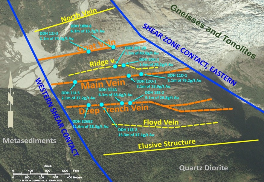
Fig. 5: Location of the New Amalga Gold Project
Kyle Mehalek, P.E.., is the QP within the meaning of NI 43-101 and has reviewed and approved the technical disclosure in this release. Mr. Mehalek is independent of Grande Portage within the meaning of NI 43-101.
About Grande Portage:
Grande Portage Resources Ltd. is a publicly traded mineral exploration company focused on advancing the New Amalga Mine project, the outgrowth of the Herbert Gold discovery situated approximately 25 km north of Juneau, Alaska. The Company holds a 100% interest in the New Amalga property. The New Amalga gold system is open to length and depth and is host to at least six main composite vein-fault structures that contain ribbon structure quartz-sulfide veins. The project lies prominently within the 160km long Juneau Gold Belt, which has produced over eight million ounces of gold.
The Company's updated NI#43-101 Mineral Resource Estimate (MRE) reported at a base case mineral resources cut-off grade of 2.5 grams per tonne gold (g/t Au) and consists of: an Indicated Resource of 1,438,500 ounces of gold at an average grade of 9.47 g/t Au (4,726,000 tonnes); and an Inferred Resource of 515,700 ounces of gold at an average grade of 8.85 g/t Au (1,813,000 tonnes), as well as an Indicated Resource of 891,600 ounces of silver at an average grade of 5.86 g/t Ag (4,726,000 tonnes); and an Inferred Resource of 390,600 ounces of silver at an average grade of 7.33 g/t silver (1,813,000 tonnes). The MRE was prepared by Dr. David R. Webb, Ph.D., P.Geol., P.Eng. (DRW Geological Consultants Ltd.) with an effective date of July 17, 2024.
ON BEHALF OF THE BOARD
"Ian Klassen"
Ian M. Klassen
President & Chief Executive Officer
Tel: (604) 899-0106
Email: [email protected]
Cautionary Statement Regarding Forward-Looking Information
This news release includes certain "forward-looking statements" under applicable Canadian securities legislation. Forward-looking statements include estimates and statements that describe the Company's future plans, objectives or goals, including words to the effect that the Company or management expects a stated condition or result to occur. Forward-looking statements may be identified by such terms as "believes", "anticipates", "expects", "estimates", "may", "could", "would", "will", or "plan". Since forward-looking statements are based on assumptions and address future events and conditions, by their very nature they involve inherent risks and uncertainties as described in the Company's filings with Canadian securities regulators. There can be no assurance that such statements will prove to be accurate, as actual results and future events could differ materially from those anticipated in such statements. Accordingly, readers should not place undue reliance on forward-looking statements. The Company disclaims any intention or obligation to update or revise any forward-looking information, whether as a result of new information, future events or otherwise, other than as required by law.
Please note that under National Instrument 43-101, the Company is required to disclose that it has not based any production decision on NI 43-101-compliant reserve estimates, preliminary economic assessments, or feasibility studies, and historically production decisions made without such reports have increased uncertainty and higher technical and economic risks of failure. These risks include, among others, areas that are analyzed in more detail in a feasibility study or preliminary economic assessment, such as the application of economic analysis to mineral resources, more detailed metallurgical and other specialized studies in areas such as mining and recovery methods, market analysis, and environmental, social, and community impacts. Any decision to place the New Amalga Mine into operation at levels intended by management, expand a mine, make other production-related decisions, or otherwise carry out mining and processing operations would be largely based on internal non-public Company data, and on reports based on exploration and mining work by the Company and by geologists and engineers engaged by the Company.
NEITHER THE TSX VENTURE EXCHANGE NOR ITS REGULATION SERVICE PROVIDER (AS THAT TERM IS DEFINED UNDER THE POLICIES OF THE EXCHANGE) ACCEPTS RESPONSIBILITY FOR THE ADEQUACY OR ACCURACY OF THIS NEWS RELEASE.
SOURCE: Grande Portage Resources Limited
View the original press release on ACCESS Newswire
(Y.Yildiz--BBZ)